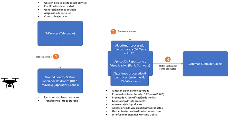
• EspañolEspañol
  • GalegoGalego
  • EnglishEnglish
GRM3D (Gestión de Recursos Marítimos - Monitorización de la Mejilla con Drones) GRM3D (Gestión de Recursos Marítimos - Monitorización de la Mejilla con Drones)
  • Home
  • About us
  • La mexilla
  • What we do
  • Application
  • News
  • Contact

What we do?

A first attempt at a more specific spatial regulation for these two resources that coexist in certain areas of the rocky intertidal, is the one introduced in the Order of December 22, 2021, which approves the management plan for the barnacle in Galicia for 2022-2024. , and in which reserve zones are established for the extraction of mussel spat and zones for the exclusive exploitation of barnacles. However, this measure has been highly controversial and has highlighted the need for exhaustive monitoring of the areas delimited for each activity, to ensure a sufficient supply for mussel aquaculture, while guaranteeing the maintenance of barnacle populations by excluding mussel seed extraction from the most sensitive areas for this species. The high spatio-temporal variability of both resources represents a significant challenge for their constant evaluation, which is at the same time essential to allow agile and sustainable management. This type of sampling, although it does provide an idea of the community structure in terms of species richness, abundance and composition, does not allow monitoring on a large spatial scale or with sufficient temporal resolution to allow certain relevant ecological processes to occur. are properly included in the management of intertidal resources.

The proposed solution aims to provide a set of tools that cover the phases of capture, cataloguing, analysis and exploitation of data related to the evolution of spat recruitment of mussels, as well as other related species, in the rocky intertidal of Galicia.

Analyze the terrain data, identifying the presence of cheek and, potentially, barnacle, as well as accompanying species present in the ecosystem, through a process of segmentation and zoning of the information collected.

The solution is made up of several integrated subsystems

The proposed solution aims to provide a comprehensive management tool for rocky intertidal, through a set of applications that cover the entire cycle of monitoring the status of resources using aerial images, as well as the possibility of integrating information on the process of extraction (potentially integrating with information extracted from TICPESC/MOVTIC), and on the historical evolution of its abundance and exploitation.
Thus, the proposed solution aims to provide a set of tools that cover the phases of capture, cataloging, analysis and exploitation of data related to the evolution of spat recruitment of mussels, as well as other related species, in the rocky intertidal of Galicia.

  • Assist in the design and planning of terrain data capture operations using UAVs.
  • Store and classify terrain data captured with UAVs through a geospatial database with the possibility of access through GIS tools
  • Present the information collected associated with the morphological characteristics of the terrain, as well as the orientation and slope of the coastline.
  • Analyze the terrain data, identifying the presence of mexilla and, potentially, barnacle, as well as accompanying species present in the ecosystem, through a process of segmentation and zoning of the information collected.
  • Have information on the areas where barnacles predominate in front of mexilla in the rocky intertidal.
  • Have information on the evolution of mexilla recruitment in the rocky intertidal in a given time interval.
  • Facilitate efficient management of marine resources, related to their impact on the rest of the species that settle on the coast.
  • Facilitate the consultation and analysis of information through advanced tools for exploiting results: visualization and consultation of current and historical data, generation of maps and reports, generation and consultation of indicators, consultation and download of information.
T-Dromes

Telespazio Drone Remote Operation Management & Exploitation Solution (T-DROMES) is an integrated solution for the exploitation of drone-based services.
T-DROMES is an RPAS (Remote Piloted Aerial Systems) fleet and mission management solution, which allows scaling the use of drones in complex operations from a geographical and mission point of view, in different application scenarios.
With T-DROMES, Telespazio has implemented a “Drone as a Service” (DaaS) business model that covers, through an integrated approach, the activities of design, planning, management and execution of unmanned aircraft systems missions ( UAS) for dedicated operations and specific application needs.

T-Dromes includes:

  • A digital platform that supports all phases of the Value Chain related to drone applications: federation of drone operators, overall mission design, authorization support, mission planning and management, data acquisition, product generation of information and access to end user data
  • A set of procedures and support services, implemented in the back-end, that manage the overall workflow related to the drone’s mission, from user requests to data exploitation.
  • Software tools and hardware payloads to federate and interconnect end-user-owned drones and third-party drone operators.
Ground Control system (GCS)

The necessary flights will be carried out according to requests through flight operators, carrying out a control of the flight mission and obtaining precision data.
These flights will be compiled and processed to obtain quality and precision data.

Efficient and precise drones will be used to which a payload will be added in the form of a very high resolution sensor.

Captured information processing algorithms

Specific photogrammetry software will be used to process the images collected from the drone and generate the DTM and the corresponding orthoimages. Although the DTM generation process is mostly automatic, given the resolution and the operating environment (intertidal coastal areas) the result will not always be completely correct.

A manual quality control has been planned to detect possible errors and correct them, since the quality of the MDT will affect the subsequent process of orthorectification of the optical and multispectral images, which are the input product of the species identification algorithms using AI.

Repository and visualization application

Given the characteristics of the data in terms of volume and type of information, as well as the processing needs, with a special focus on privacy, security and availability, a cloud storage and processing architecture offered by Amazon Web Services (AWS) is proposed. ). The solution will be scalable and will be based on open technologies and standards.

AI mexilla identification processing algorithms

For mexilla identification, a software module for segmentation and classification of objects of interest based on Artificial Intelligence algorithms will be developed. This module will take the input orthorectified images provided by the system and process them to provide information on the regions where the presence of mexilla is identified. Additionally, the possibility of incorporating into the training database samples corresponding to oblique images for those areas with very steep slopes will be assessed. Adding additional classes related to other species, such as barnacles, will also be considered.

Copyright @ 2023 Telespazio Ibérica

Privacy Policy

Cookies policy

This publication has been the result of the services and works with co-financing from the Galician Innovation Agency (GAIN) and Telespazio and/or subcontractors. The opinions expressed in this publication are those of the author(s) and not necessarily those of the co-financing entities.

This publication has been financed by the European Union – NextGenerationEU. However, the views and opinions expressed are solely those of the author(s) and do not necessarily reflect those of the European Union or the European Commission. Neither the European Union nor the European Commission can be held responsible for them.

Copyright © 2023 Telespazio Ibérica.
We use cookies on our website to give you the most relevant experience by remembering your preferences and repeat visits. By clicking “Accept All”, you consent to the use of ALL the cookies. Read More
Accept AllReject All
Cookies Policy

Privacy Overview

This website uses cookies to improve your experience while you navigate through the website. Out of these, the cookies that are categorized as necessary are stored on your browser as they are essential for the working of basic functionalities of the website. We also use third-party cookies that help us analyze and understand how you use this website. These cookies will be stored in your browser only with your consent. You also have the option to opt-out of these cookies. But opting out of some of these cookies may affect your browsing experience.
Necessary
Siempre activado
Necessary cookies are absolutely essential for the website to function properly. These cookies ensure basic functionalities and security features of the website, anonymously.
CookieDuraciónDescripción
cookielawinfo-checkbox-analytics11 monthsThis cookie is set by GDPR Cookie Consent plugin. The cookie is used to store the user consent for the cookies in the category "Analytics".
cookielawinfo-checkbox-functional11 monthsThe cookie is set by GDPR cookie consent to record the user consent for the cookies in the category "Functional".
cookielawinfo-checkbox-necessary11 monthsThis cookie is set by GDPR Cookie Consent plugin. The cookies is used to store the user consent for the cookies in the category "Necessary".
cookielawinfo-checkbox-others11 monthsThis cookie is set by GDPR Cookie Consent plugin. The cookie is used to store the user consent for the cookies in the category "Other.
cookielawinfo-checkbox-performance11 monthsThis cookie is set by GDPR Cookie Consent plugin. The cookie is used to store the user consent for the cookies in the category "Performance".
viewed_cookie_policy11 monthsThe cookie is set by the GDPR Cookie Consent plugin and is used to store whether or not user has consented to the use of cookies. It does not store any personal data.
Functional
Functional cookies help to perform certain functionalities like sharing the content of the website on social media platforms, collect feedbacks, and other third-party features.
Performance
Performance cookies are used to understand and analyze the key performance indexes of the website which helps in delivering a better user experience for the visitors.
Analytics
Analytical cookies are used to understand how visitors interact with the website. These cookies help provide information on metrics the number of visitors, bounce rate, traffic source, etc.
Advertisement
Advertisement cookies are used to provide visitors with relevant ads and marketing campaigns. These cookies track visitors across websites and collect information to provide customized ads.
Others
Other uncategorized cookies are those that are being analyzed and have not been classified into a category as yet.
GUARDAR Y ACEPTAR